Uinta Highline Trail Thru-Hike
Uinta Highline Trail Thru-Hike

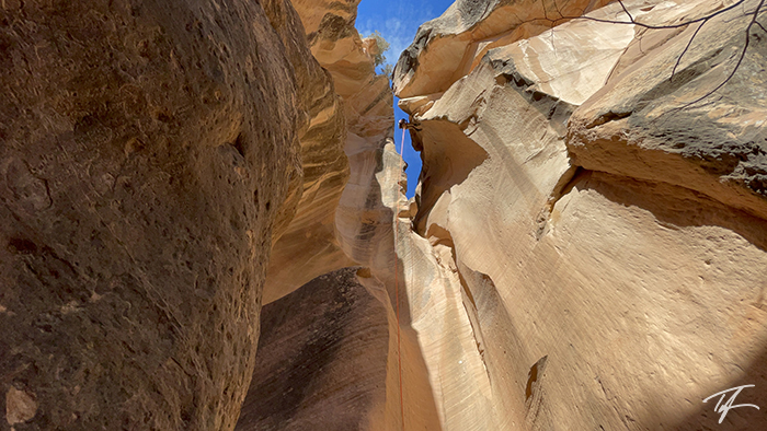
Top of Gabbro Pass above Lake Wilde on the Uinta Highline Trail
About the Uinta Highline Trail
The Uinta Highline Trail crosses most of the length of the Uinta Mountains, the largest major east-west mountain range in the United States. 14 miles (35.5 km) in, the trail climbs above 10,000 feet (3,048 m) and stays above that elevation for the next 82 miles (132 km) with only a few brief drops barely below. Four mountain passes exceed 12,000 feet (3,657 m). It's important to know that elevation sickness can be a real problem. From Anderson Pass, hikers can easily access Kings Peak, Utah's highest point of 13,528 feet (4,123 m) with a 1.5 mile (2.4 km) out-and-back detour.
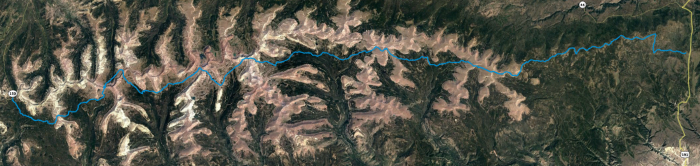
Four trailheads have relatively easy access to the Uinta Highline Trail. To hike the trail's full length of 104 miles, the eastern terminus is at McKee Draw trailhead (near US 191) and the western terminus is at Hayden Pass trailhead on the Mirror Lake Highway (UT 150). Hikers can do shorter distances of 79 miles (127 km) by starting at Leidy Peak trailhead, or 69 miles (111 km) by starting at Chepeta Lake trailhead. The Uinta Highline Trail is very remote wilderness, with no easy resupply options, so hikers must plan on taking everything they need for their entire distance.
The Uinta Highline Trail stays on the south slope of the Uinta Mountains for nearly its entire length and is above the tree line for much of the time. The trail climbs and descends several rocky passes, wanders through expansive meadows (called parks), glacial carved valleys and basins, and has easy access to numerous lakes and streams. The only time the trail is on the north slope of the range is between Red Knob and Dead Horse passes.
| Full Length—McKee Draw trailhead to Hayden Pass trailhead | 104 mi | 167 km |
| Lowest Elevation—Cart Creek near McKee Draw trailhead | 8,189 ft | 2,496 m |
| Average Elevation | 10,722 ft | 3,268 m |
| Highest Elevation—Anderson Pass | 12,667 ft | 3,860 m |
| Elevation Gain Elevation Loss |
18,174 ft -16,030 ft |
5,539 m -4,885 m |
| Max Slope—Dead Horse Pass (east side), Anderson Pass (west side) |
36.8% -28.7% |
|
| Average Slope | 6.0% -6.3% |
|
McKee Draw to Leidy Peak Trailhead
I have three words for this section of trail. Don't do it.
Seriously, this section of trail—if you can call it that—is not worth the time or effort.
Except for crossing a few meadows, this section is very forested and only has a view or two of Flaming Gorge—if you're paying close attention. It crosses a lot of gravel and dirt roads with a whole lot of not much more to see.
If you do decide to do it, know this. You will lose the trail—many times. Bring a GPS device with a track of the trail so you can find it again when you do. We lost the trail about a dozen times, but luckily found it again the same amount of times. One time we were off trail, we even came across a hiker that had spent a good amount of the day off the trail and hadn't been able to find it again. She was using paper maps and I'm not sure how she would be able to know exactly where she was at without her exact GPS position and a GPS track to follow.
Know that there is absolutely no water to be found for about a 15 mile stretch. Top up at East Park Reservoir. Many recent hikers didn't find water again until a stagnant water pool at Summit Park. However, we stumbled across a spring at the top of Lost Park which is the headwaters of Center Creek northeast of Trout Creek Peak. We only happened across the spring because we were off trail again.
Also, the trail was much longer than we expected. We planned our first camp to be about a half-mile west of Summit Park. According to Google Earth and the GPS track we had loaded, that was supposed to be 20 miles in. After hiking nearly 13 hours the first day, we decided to camp on the east end of Summit Park. Both my smartwatch and my brother's smartwatch (different brands) were within a half-mile of each other in saying that we had hiked 24.5 miles.
We never did find the watering hole at Summit Park. But before reaching the Leidy Peak trailhead on the east side of the mountain, the trail crossed a canal where we were able to fill up again.
The official Uinta Highline Trail should begin at Leidy Peak and not be advertised as going all the way to McKee Draw. The Forest Service should actively discourage anyone from hiking between those two points. Or, they need to make a serious effort to mark the trail better.
Leidy Peak to Chepeta Lake Trailhead
The trail from Leidy Peak trailhead is very easy to follow until you get up above the treeline. Cairns are few and far between and don't do very well marking the trail again until you drop below the treeline. We took lunch barely off the point on the west side of Leidy Peak. I took off a shoe and discovered I had several very large blisters on my feet. We also had cell service. Realizing how bad my feet were, how far behind we were, and how much of the trail we still had left, I asked a friend if he could pick me up at Chepeta Lake the next day.
At one point, as we were crossing the tundra I felt and heard what might have been a plum being squished under my left foot. I later found out that it was a massive blister on the large pad of my foot. My feet hurt, but we had to keep on trudging until we set up camp at Whiterocks Lake—seven miles short of where we had planned for that night.
The next morning we hiked about four miles to Chepeta Lake where I caught my ride home.
According to our two smartwatches, it seems that the stretch from McKee Draw to Chepeta Lake is actually closer to 45 miles than the commonly reported 36 miles.
Planning the remainder of my Uinta Highline Trail thru-hike
I haven't given up on finishing what I started. I plan on doing the remaining section from Chepeta Lake to the Hayden Pass trailhead—hopefully next year. However, I'm not going to try and push it as hard as I had originally planned. I think my mistakes on my feet was threefold.
- My shoes needed to have thicker soles for the constant stepping on rocks
- We hiked too many miles the first day getting my feet too hot
- I needed more opportunities in camp and on trail to let my feet cool down and rest.
The following is the plan for when I finish the trail (mileage estimates are likely inaccurate).
Day 1
- Chepeta Lake—0 mi (10,588 ft)
- Sharlee Lake—1.4 mi (10,746 ft)
- Reader Creek—2.1 mi (10,794 ft)
- Taylor Lake—3.7 mi (11,528 ft)
- North Pole Pass—5.7 mi (12,254 ft)
- Brook Lake—7.8 mi (11,056 ft)
- Fox Lake—8.6 mi (10,812 ft)
- Camp 1 at Kidney Lakes—13.1 mi (10,814 ft)
- 13.1 miles
Day 2
- Gilbert Creek #1—15.3 (10,563 ft)
- Gilbert Creek #2—16.5 mi (10,844 ft)
- Uinta River—19.1 mi (11,135 ft)
- Trail split to Gunsight Pass—20.3 mi (11,267 ft)
- Anderson Pass—22.6 mi (12,667 ft—HIGHEST POINT OF TRAIL)
- Kings Peak—approx. 1.75 mi RT (13,528 ft—HIGHEST ELEVATION)
- Camp 2 at Yellowstone Creek—25.3 mi (11,029 ft)
- 12.2 miles without Kings Peak
- approx. 14.0 miles including Kings Peak
Day 3
- Tungsten Pass—27.5 mi (11,428 ft)
- Tungsten Lake—27.7 mi (11,346 ft)
- North Star Lake—28.3 mi (11,404 ft)
- Porcupine Pass—30.0 mi (12,214 ft)
- Headwaters of Oweep Creek—31.9 mi (10,354 ft)
- Oweep Creek—33.0 mi (11,107 ft)
- Paradise Lake—35.6 mi (11,148 ft)
- Camp 3 at Lambert Lake—36.5 mi (11,142 ft)
- 11.2 miles
Day 4
- Lake Fork River—38.5 mi (10,391 ft)
- Red Knob Pass—41.9 mi (12,000 ft)
- Tributary of West Fork Blacks Fork River—43.3 mi (10,844 ft)
- Dead Horse Lake—44.7 mi (10,907 ft)
- Dead Horse Pass—45.6 mi (11,585 ft)
- Ledge Lake (top of Fall Creek Drainage)—47.1 mi (10,868 ft)
- Camp 4 at Rock Creek—50.7 mi (9,876 ft)
- 14.2 miles
Day 5
- Unnamed lake on climb of Rocky Sea Pass—52.9 mi (10,832 ft)
- Rocky Sea Pass—53.3 mi (11,257 ft)
- Pigeon Milk Spring—54.5 mi (10,701 ft)
- Olga Lake—54.8 mi (10,594 ft)
- Naturalist Basin turn off—approx. 57.2 mi (10,224 ft)
- Scudder Lake—59.1 mi (10,065 ft)
- Hayden Pass trailhead—61.0 mi (10,378 ft)
- 10.3 miles
Photo Gallery