Epic Road Trip!
Epic Road Trip!

Buckskin Gulch in Grand Staircase-Escalante National Monument
The plan was for three friends to drive down on Wednesday, hike Buckskin Gulch on Thursday and Friday, and return home on Saturday. Things didn't go according to plan, but I wouldn't have it any other way as we flew by the seat of our pants for four days.
Wednesday
Late afternoon and evening is just traveling to find a place to camp near the Paria Contact Station. Passing through Mount Carmel Junction, we stop at Thunderbird Lodge—to check out their "ho-made pies." We'll check-in with the Contact Station in the morning to pick-up our permit to hike Buckskin Gulch.
Thursday
6:58a—A beautiful sunrise lights up the scattered clouds over the white and brown sandstone cliffs of the White House Trailhead and Campground. Let's go get our permit.
Unfortunately, there's been rain recently and rain is forecasted for later today. They've had recent major flooding through the gulch and it's not safe for us to enter today. We will try again tomorrow—if the forecast is more favorable.
Hmmm... What to do... Let's head to Kanab and salvage the day by trying to get a permit into The Wave.
8:00a—There's only space for 12 people in this morning's lottery... unfortunately we didn't get drawn and have to figure something else out.
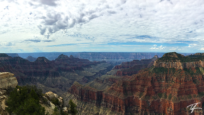
None of us have been to the Grand Canyon. Let's go!
As we enter the park, I decide to purchase an annual pass since we'll probably visit Zion on our way home Saturday.
11:47a—We're standing on the North Rim of the Grand Canyon. What an amazing site!
One of my friends says he wants to get a medallion for his hiking staff but has a personal rule that he can't get one unless he does a hike in the park.
1:09p—We've had lunch and are now hiking down the North Kaibab Trail.
1:54p—After less than an hour, we've hiked 3.7 miles and descended into the canyon 1,400 feet and turn around at the Supai Tunnel.
Now what? We decide to head back towards the Contact Station by way of Vermillion Cliffs National Monument and Page, Arizona—completing a loop.
5:41p—We stop at the Navajo Bridge over the Colorado River's Marble Canyon for pictures.
7:37p—As we near Page, we realize that we're passing the famous Horseshoe Bend. We make a U-turn and end up watching the sunset and distant rain before we head back to the vehicle and grab dinner in Page.
8:30p—I insist on stopping for some pictures at Glen Canyon Dam.
Friday
After getting our permit at the Contact Station, we head to our planned entrance to the gulch.
10:56a—It didn't look that steep on my map. The slickrock slope entering the canyon below the gulch is long and steep. We could probably get in, but getting out at this point would be our biggest challenge. Plus, the rangers said that they don't know what the conditions are in the gulch as no one's been through that part for a while.
Change of plans. Let's ditch the overnight packs and just find the middle entrance and day hike up and down as far as we want and then come out. When we sign in at the middle entrance log book, the last entry was four days earlier. It gives you a sense of "if something went wrong, it might be awhile before someone finds you."
1:04p—After following, losing, and re-finding cairns marking the direction to the middle entrance—and after a very sketchy traverse next to a cliff dropping directly into the gulch, we literally slide our way down into the gulch. A petroglyph of a pair of bighorn sheep etched into the rock identifies the middle entrance to anyone in the gulch.
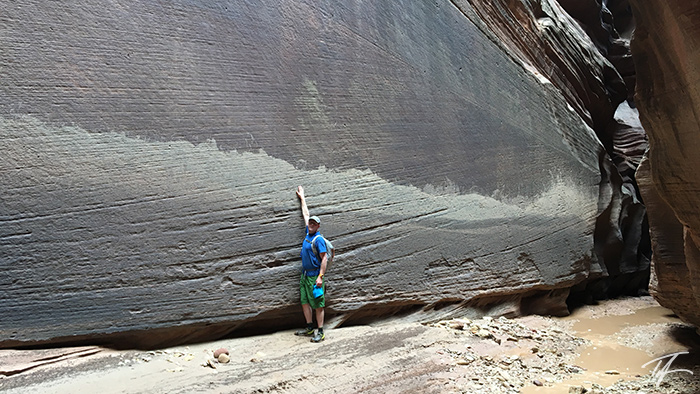
Buckskin gulch is amazing as the cliffs meander up and down stream, with undulating waves of rock that are less than six feet apart in spots reaching upwards of 200 feet above your head. You are at the mercy of the gulch with nowhere to escape if you needed to. I can definitely see why you don't want to be in here if rain is in the forecast.
We headed upstream for awhile, and then back downstream below the middle entrance until we came to a massive debris dam. Along the way, we see a recent high water mark. This probably happened a month ago when the nearby town of Kanab was recently in the news for massive flooding. All that water drains down Buckskin Gulch. In the picture below, my friend stands on a sandbar about three feet higher than the lowest point of the stream flowing through the gulch. He reaches high and still comes short of the marks of lapping water against the sheer cliff face.
As we got back to the level trail, almost back to the vehicle, a rainstorm brushed over us. It's probably a good thing that we decided to just make this a day hike in the gulch.
It was late afternoon when we got back to the vehicle. Hmm... well, we're done with the gulch much sooner than we expected. Now what?
Let's go to Zion National Park!
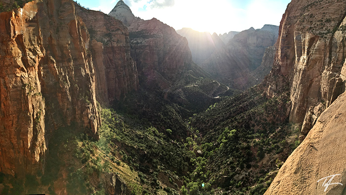
As we approach the Mount Carmel Tunnel in Zion, we spot bighorn sheep along Pine Creek. We stop and take some photos. I suggest we hike the Canyon Overlook trail since we're here.
6:59p—The sun is nearing the horizon across the massive cliff walls of Zion Canyon.
We stop in at the Visitors Center and let my friend pick up his hiking medallion. The shuttles are almost done running for the day, so we can't go up canyon tonight.
We find a spot to camp just off the Kolob Reservoir road north of Virgin, Utah with the plan to get up early and do another hike in Zion Canyon tomorrow.
Saturday
It was very early when we got up and back to the Visitors Center and boarded a shuttle. It wasn't very crowded—yet.
8:12a—We're the only ones at the Upper Emerald Pools for the first 15 minutes we're there. I've never experienced that! I've never been alone for even a moment at any of the Emerald Pools.
Two of us wanted to hike Angel's Landing, but one of us wasn't keen on the idea after we did the 1,400 foot descent and then climb in the Grand Canyon two days ago.
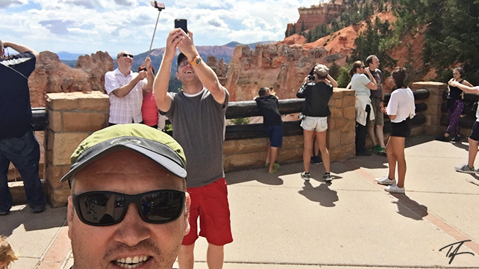
Before we got back to the shuttle, we saw a couple taking a selfie... I'm not sure who came up with the idea, but one of us three said, When one of us sees someone taking a selfie, yell "squirrel." Then, let's line up and take selfies of each other taking selfies of that person—kind of like a selfie-Inception.
As we return to the Visitors Center on an otherwise empty shuttle, we are greeted by a massive line of people snaking all the way past the Visitors Center bathrooms—100 yards long.
Okay... now what? Oooh... I know... Let's go to Bryce Canyon!
12:07p—We enter Bryce Canyon National Park.
Squirrel!
1:17p—We hike the Navajo Loop trail before having lunch. While having lunch we post pictures of our trip to various social media and check-in with our wives. We stop in at the Visitors Center. Now I wish I had been getting hiking medallions at each stop along the way.
I don't know who suggested it, but we decided to head to Capitol Reef National Park as it was "on our way" back towards our homes in northern Utah. We drove to Capitol Reef by way of Scenic Highway 12 through Escalante and Boulder. What an amazing road! Don't miss this opportunity if you're traveling between Bryce and Capitol Reef.
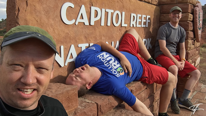
5:47p—We stop at the entrance sign and get a picture.
As we pull up to the Visitors Center, we see that they're closing in just minutes. My friend purchases his medallion and we ask what hike we could do that's short.
6:51p—We're standing under Hickman Natural Bridge.
7:24p—Just after we see the double rainbow over the Capitol Dome with the sun setting behind us, we check our social media feeds and noticed that one of our wives commented on a Bryce Canyon post. "Sheesh, what national park haven't you been to?" (Not knowing that we had gone to Capitol Reef) Another replied, "I know... right?!!"
We're beat. We've had an eventful three days already... but... those comments invigorated us. We got another hair-brained idea on top of everything we've done so far...
We could be in Moab at about 10:00 or 10:30. And, if we got up really early, we could do two more hikes... one in Arches, and one in Canyonlands... If we can, we would accomplish five hikes in all of Utah's "Mighty Five" parks in 24 hours.
As Barney from How I Met Your Mother would proclaim, "Challenge accepted!"
And we were off... You would have thought that all three of us had just drank a dozen energy drinks. With renewed enthusiasm, we jumped in the vehicle, and pushed on towards our next new goal.
Sunday
Just past dark-thirty, we took down camp and easily drove into Arches where we watched the sunrise under South Window Arch and saw a double rainbow over Turret Arch. We did our shortest hike in this park, but it still earned a medallion on our way out. Vehicles were now lined up out to the highway waiting to get into the park.
We hurried off to Canyonlands and pulled in behind two other vehicles paying their entrance fee. It's a good thing I had purchased that annual pass—it more than paid for itself on this trip alone.
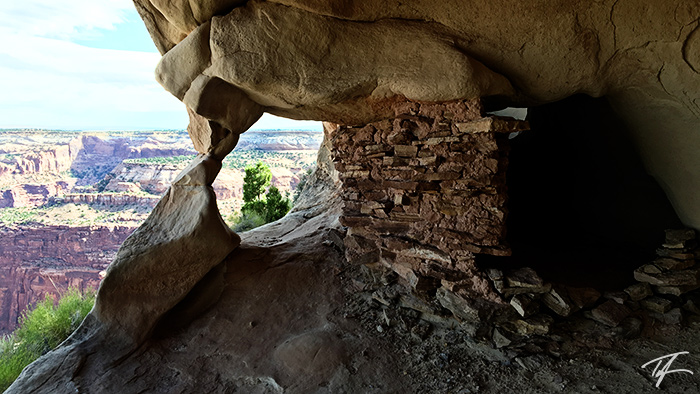
9:06a—We were on our final hike of the trip. This one is to some Native American dwellings on the Aztec Butte trail. It was amazing to realize that just 24 hours ago, we were finishing up our hike on the Emerald Pools trail in Zion. Since then we've hiked in Bryce, Capitol Reef, Arches, and now Canyonlands.
On our way out of the park, vehicles were lined up for a mile waiting to get in. Did I mention it's Labor Day Weekend?!! It's a good thing I had Monday off to recover from this epic road trip.
In Retrospect
Even though our original plan fell apart, I wouldn't have it any other way. In less than four days we did eight hikes, saw six national parks, two national monuments, saw Horseshoe Bend and Glen Canyon Dam.
Our timing of everything was perfect—it had to be! It was a holiday weekend and if everything didn't fall into place like it did, we would have been caught in the crowds.
We had a plan, but flying by the seat of our pants, not really knowing what we're doing two hours after each adventure was an absolute blast and this trip contains a lifetime's worth of memories and checks off bucket list items galore. Given the chance, I would repeat this trip again without hesitation. I hope to do something like this again—just as spontaneous!
I still want to go back and hike all of Buckskin Gulch.
Photo Gallery


Trending Outdoor Articles


